Nossos Serviços

Oferecemos soluções precisas em topografia e georreferenciamento e ASTEC Rural com Atendimento Personalizado

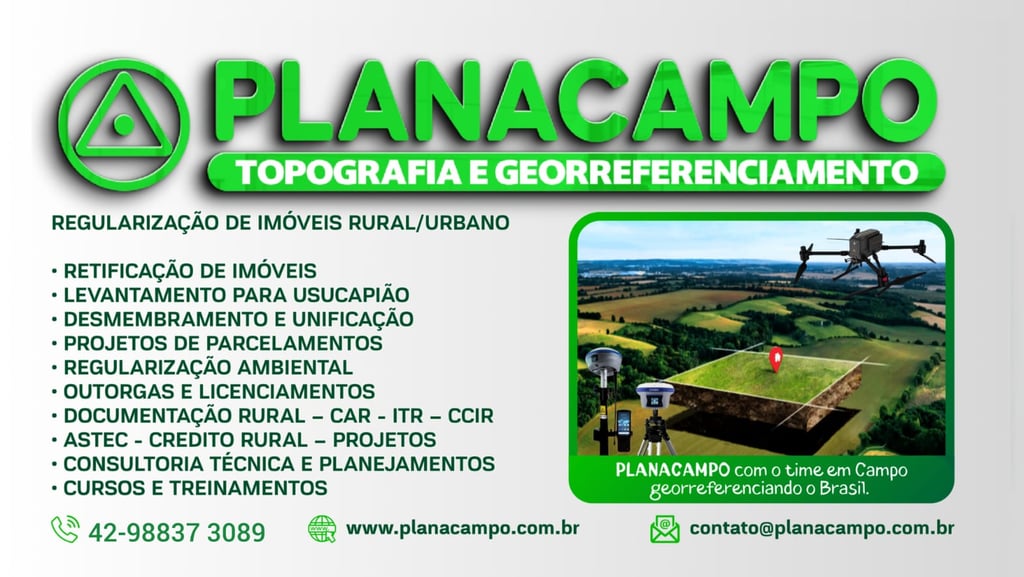
Topografia Especializada

Serviços de topografia com precisão e qualidade para diversos tipos de projetos.

Georreferenciamentos

Realizamos georreferenciamento com tecnologia de ponta para garantir a confiabilidade dos dados.

Assistência Técnica

Oferecemos suporte técnico especializado para atender às necessidades dos nossos clientes produtores rurais bem como assistência ao credito rural e assistência voltada a produção agropecuária, desde o plantio até a colheita.

Saiba Mais 👇

Nossos Projetos

Soluções precisas em topografia e georreferenciamento para você.

A table features a topographic map with detailed contours and vibrant colors. A knife with a wooden handle is placed nearby, next to a plastic water bottle. Sunlight casts dramatic shadows across the wooden surface, creating an adventurous atmosphere.
Topografia Avançada

Serviços de topografia com tecnologia de ponta e precisão.

A close-up view of a topographical map featuring a grid overlay. The map highlights the 'Emigrant Trail' and 'BLM' in bold text. There are marked trails with dashed lines and various geographical features such as contours and elevations.
Georreferenciamento

Georreferenciamento de propriedades com total confiabilidade e eficiência.

Aerial view of a highly detailed geographical landscape, potentially a mountainous or volcanic region. Various water bodies in shades of blue are scattered across the terrain, surrounded by rugged hills, peaks, and valleys. The landscape features a mix of different textures, including rocky and potentially sandy areas, with a palette of colors ranging from earthy browns and greens to blues and grays.
A satellite image showcasing diverse landforms with varying colors. Red and brown regions appear to highlight elevation or different terrain, while greens and blues may represent vegetation or bodies of water. The image has a mix of organic patterns indicating natural landscapes.
Assistência Técnica

Suporte técnico especializado para atender suas necessidades específicas.

Projetos Personalizados

Desenvolvemos projetos sob medida para empresas e particulares.

A Empresa Planacampo superou nossas expectativas com serviços de topografia precisos e confiáveis. Recomendo para quem busca qualidade e eficiência em projetos técnicos.

João Silva

An aerial view of a landscape with intricate patterns and textures. Light earthy tones blend into darker areas, indicating possible riverbeds or erosion lines on a rugged terrain.

★★★★★